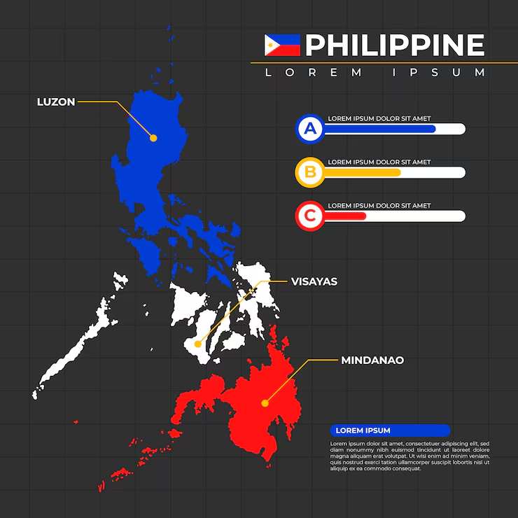
The Philippines map offers a fascinating look at one of the world’s most geographically diverse island nations. Located in Southeast Asia, the Philippines consists of thousands of islands spread across the western Pacific Ocean. Its location, physical geography, provinces, major cities, and three primary island groups make understanding a map of the country especially useful for travelers, students, researchers, and anyone interested in Southeast Asia.
The Philippines is commonly divided into three major geographical groups: Luzon, Visayas, and Mindanao. These regions contain numerous provinces, cities, mountains, rivers, beaches, and other geographical features. Looking at a detailed Philippines map makes it easier to understand how these areas connect and where important destinations are located.
This guide explains the country’s geographical position, major island groups, regions, cities, provinces, and key features in a simple and informative way.
Where Is the Philippines Located?
The Philippines is an archipelagic country in Southeast Asia. It lies in the western Pacific Ocean, east of Vietnam and north of Indonesia. Taiwan is located to the north across the Luzon Strait.
The country’s position gives it an important place between mainland and maritime Southeast Asia. Because the Philippines is surrounded by several seas and channels, its geography has strongly influenced its history, economy, culture, transportation, and tourism.
A Philippines map typically shows the country stretching from north to south across a large area of ocean. Rather than forming one continuous landmass, the country is made up of thousands of islands.
Countries and Areas Near the Philippines
The Philippines is relatively close to several countries and territories, including:
- Taiwan to the north
- Vietnam to the west
- Malaysia to the southwest
- Indonesia to the south
- Various Pacific island areas to the east
Its maritime location also means that different bodies of water surround and separate its islands.
The Three Major Island Groups
One of the most important things to understand when reading a Philippines map is the country’s division into Luzon, Visayas, and Mindanao.
These three island groups are widely used when describing the country’s geography and administrative organization.
1. Luzon
Luzon is the largest and most populous island group in the Philippines. It includes the main island of Luzon as well as many smaller surrounding islands.
The national capital, Manila, is located on Luzon. The broader metropolitan area known as Metro Manila is a major center of government, business, education, transportation, and culture.
Other important places associated with Luzon include Quezon City, Baguio, Batangas, Pampanga, and the Bicol region.
Northern Luzon is known for mountainous landscapes, agricultural areas, and distinctive cultural communities. Central Luzon contains important agricultural and industrial areas, while southern Luzon includes volcanic landscapes, coastal communities, and popular tourist destinations.
2. Visayas
The Visayas occupies the central portion of the Philippines. It is composed of numerous islands, including some of the country’s best-known tourist destinations.
Major islands and areas include:
- Panay
- Negros
- Cebu
- Bohol
- Leyte
- Samar
Cebu City is one of the major urban centers in the Visayas and is an important commercial and transportation hub.
The Visayas is particularly famous for its beaches, coral reefs, historic sites, waterfalls, and island communities. A map helps travelers understand the distances between destinations that may appear close together geographically but require flights, ferries, or other transportation.
3. Mindanao
Mindanao is the second-largest major island group and occupies the southern part of the country.
Important cities include Davao City, Cagayan de Oro, General Santos, and Zamboanga City. Mindanao has extensive agricultural areas and is known for mountains, forests, rivers, coastal landscapes, and diverse communities.
Mount Apo, the highest mountain in the Philippines, is located on Mindanao.
Because Mindanao is large and geographically diverse, a detailed map can be particularly helpful when exploring its provinces and cities.
Administrative Regions on a Philippines Map
The Philippines is divided into administrative regions and provinces to make government administration and geographic organization easier.
A modern map may display regions using different colors or boundaries, allowing users to distinguish one administrative area from another.
The country has regions covering Luzon, the Visayas, and Mindanao, along with the Bangsamoro Autonomous Region in Muslim Mindanao (BARMM) and special administrative areas.
Why Regional Maps Are Useful
A regional Philippines map can help users:
- Identify provincial boundaries
- Locate major cities
- Understand administrative divisions
- Plan road and ferry journeys
- Compare distances between destinations
- Study population and economic patterns
- Understand local geography
For students, regional maps are especially useful because they connect geographical information with political and administrative organization.
Major Cities to Find on a Philippines Map
The Philippines has many important cities, but several stand out because of their population, economy, transportation networks, or cultural importance.
Manila
Manila is the national capital and one of the country’s most historically significant cities. It sits on the eastern shore of Manila Bay on Luzon.
Quezon City
Quezon City is part of Metro Manila and is a major center for government institutions, education, business, and residential communities.
Cebu City
Cebu City is a major urban center in the Visayas. Its location makes it an important gateway to nearby islands and tourist destinations.
Davao City
Davao City is located in southeastern Mindanao and is one of the country’s major urban centers. Its surrounding region is known for agriculture, mountains, and diverse natural environments.
Zamboanga City
Located in southwestern Mindanao, Zamboanga City is an important commercial and cultural center with access to surrounding islands and coastal areas.
Important Physical Features on the Philippines Map
A physical map focuses less on political boundaries and more on mountains, rivers, seas, valleys, forests, and other natural features.
The Philippines has highly varied terrain because of its geological history and location along the Pacific Ring of Fire.
Mountains and Volcanoes
The country contains numerous mountains and volcanoes. Some are active, while others are dormant or inactive.
Mount Apo is the country’s highest mountain. Mayon Volcano in Albay is another famous geographical landmark, recognized for its distinctive symmetrical cone.
Mount Pinatubo, located in the Luzon region, is also internationally known because of its major volcanic eruption in 1991.
These features are often clearly marked on detailed physical maps.
Rivers and Lakes
The Philippines has many rivers and inland bodies of water. Some of the country’s major river systems are important for agriculture, communities, transportation, and ecosystems.
The Cagayan River, located in northern Luzon, is the longest river in the Philippines.
Laguna de Bay, southeast of Metro Manila, is the country’s largest lake by surface area and is an important geographical feature of Luzon.
Seas and Bodies of Water
Because the Philippines is an archipelago, water plays a central role in its geography.
A Philippines map may identify several important bodies of water, including:
- Philippine Sea
- South China Sea
- Sulu Sea
- Celebes Sea
- Luzon Strait
- Visayan Sea
- Sibuyan Sea
These bodies of water separate islands and influence weather, fishing, transportation, and trade.
Why the Philippines Map Matters for Travelers
A map is one of the most useful tools for planning a trip around the Philippines. The country’s island geography means that traveling between destinations can involve several different forms of transportation.
For example, a traveler visiting Manila, Cebu, Palawan, and Davao should understand that these locations are not connected by a single continuous road network.
Using a Map to Plan Island Travel
Before traveling, it helps to identify:
- Your starting city
- Your destination island
- The nearest airport
- Available ferry routes
- Road connections
- Approximate travel distances
- Nearby attractions
This is particularly important when planning multi-island trips.
Philippines Map for Students and Education
Maps are valuable educational tools because they make geographical concepts easier to visualize.
Students can use a Philippines map to study:
- Island groups
- Provinces and regions
- Climate patterns
- Mountains and volcanoes
- Major rivers
- Population centers
- Economic regions
- Transportation routes
- Neighboring countries
A political map is useful for learning administrative boundaries, while a physical map provides a better understanding of terrain and natural features.
Different Types of Philippines Maps
Not every map serves the same purpose. Depending on what you want to learn, you may find several useful formats.
Political Map
A political map emphasizes provinces, regions, cities, and boundaries. It is useful for understanding how the country is administratively organized.
Physical Map
A physical map highlights mountains, rivers, lakes, coastlines, and other natural features.
Road Map
A road map focuses on highways, major roads, towns, and transportation connections. It can be useful for planning journeys on larger islands.
Tourist Map
Tourist maps usually highlight attractions, beaches, historical landmarks, airports, resorts, and popular destinations.
Blank Philippines Map
A blank map is especially useful for students. It can be used for geography exercises where learners label provinces, cities, islands, or bodies of water themselves.
How to Read a Philippines Map
Reading a map becomes easier when you understand a few basic elements.
First, check the legend, which explains symbols and colors. Next, look at the scale to understand approximate distances. The compass or north arrow shows direction.
When examining an island map, pay attention to the surrounding bodies of water. This can help explain why some destinations require air or sea transportation even when they appear relatively close.
Map labels can also vary depending on the map’s purpose. A tourist map may emphasize attractions, while an administrative map may show detailed provincial boundaries.
The Philippines and Its Geographic Diversity
The Philippines’ geography is one reason the country has such a wide variety of landscapes and ecosystems.
Visitors can find tropical beaches, coral reefs, rice terraces, dense forests, volcanic mountains, waterfalls, caves, and large urban areas within the same national territory.
The country’s geography has also contributed to cultural diversity. Communities developed across many islands and regions, resulting in numerous languages, traditions, cuisines, and local identities.
A map provides a useful starting point for understanding this diversity because it shows how communities and environments are distributed across the country.
Frequently Asked Questions About the Philippines Map
1. How many islands are in the Philippines?
The Philippines is commonly described as having more than 7,600 islands, although the exact count can vary depending on mapping and geographic classification. The number can also change as previously unmapped or newly recognized land features are documented.
2. What are the three main island groups of the Philippines?
The three main island groups are Luzon, Visayas, and Mindanao. They are commonly used to describe the country’s broad geographical divisions.
3. Where is Manila located on the Philippines map?
Manila is located on the island of Luzon, along the eastern shore of Manila Bay. It is the national capital and part of the larger Metro Manila metropolitan area.
4. Which is the largest island in the Philippines?
Luzon is the largest island in the Philippines by land area. It is also home to Manila and contains many of the country’s major economic and population centers.
5. Why is the Philippines difficult to represent on a simple map?
The Philippines is an archipelago made up of thousands of islands spread across a large maritime area. A simple map may not show every island, province, or geographical feature, so detailed maps are often needed for accurate geographic study.
Conclusion
The Philippines map is more than a simple collection of islands and boundaries. It provides a visual explanation of how one of Southeast Asia’s most geographically diverse countries is organized. From the major island groups of Luzon, Visayas, and Mindanao to its mountains, volcanoes, cities, provinces, and surrounding seas, the map reveals the country’s remarkable physical and cultural variety.
Whether you are a student studying geography, a traveler planning an island-hopping adventure, or simply curious about Southeast Asia, learning to read a Philippines map can give you a much clearer understanding of the country. By combining political, physical, regional, and tourist maps, you can explore the Philippines with a better sense of location, distance, and geographic context.